An interesting year for a systems scientist
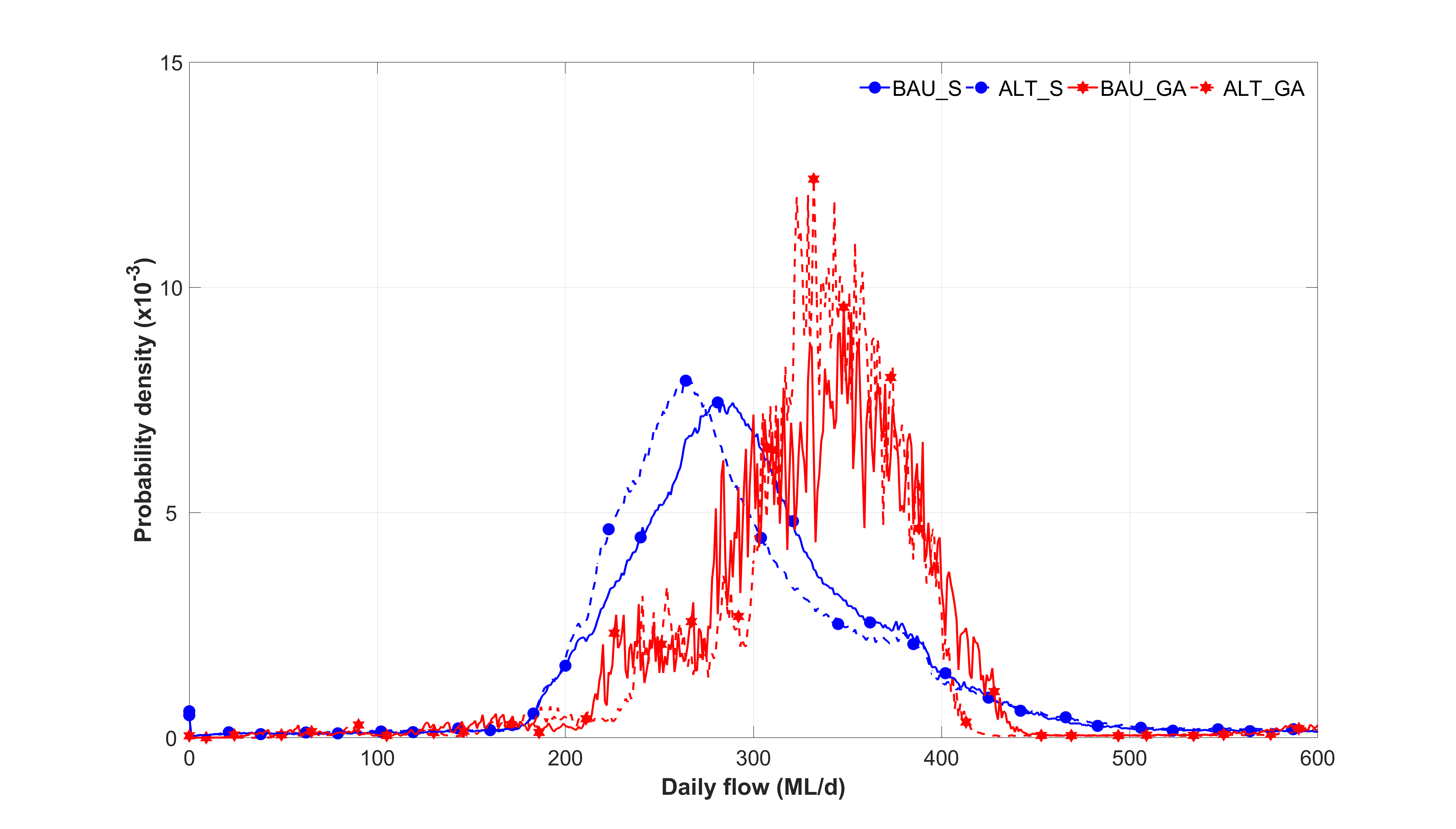
Joint probability of local rainfall and peak flows in a regional river
It has been an interesting and productive year that included fascinating applied science and policy projects, research activity and contributions to legal, economic and planning domains.
This blog provides a summary of some of the interesting projects and responds to a request for more information about our recent projects and research. The journey involves some important considerations from different domains:
- Who pays for conservative assumptions?
- The importance of a proper purpose in Policy and planning decisions
- The need to apply joint probability to stormwater and water resources decisions
- Averages and maximum assumptions can be highly misleading
- The need for whole of society and equity perspectives in economic policy
- A quest for the truth and best science answers is essential
The Research Contribution
The following research papers were published during 2022:
- Coombes P.J., (2022), Borrowing from nature to create self organising systems frameworks of big data to understand urban water systems, Social Responsibility in Algorithms Conference, Australian National University, Canberra
- Coombes P. J., (2022), A systems perspective on characterising resilience in urban water markets, OzWater 22 Conference, Australian Water Association, Brisbane
- Coombes P.J., and Allan A.A., (2022), Is zero afflux the question or answer to better flooding outcomes? International Hydrology and Water Resources Symposium, Engineers Australia, Brisbane
These research papers present the ongoing systems inquiry into the need for emerging science in policy domains, and the development of methods to better understand whole of society, economic and biosphere interactions. Understanding the joint probability of these interactions is essental and unlikely to be revealed by cumulative maximum assumptions. These investigations examine reasonableness of assumptions from a scientific, economic and legal perspective. Additional research investigations include:
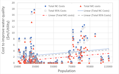
- the costs of improving water supplies to achieve good water quality to remote and indigenous communities,
- resolving the joint probability of regional rivers, local stormwater runoff, ocean tides and climate change
- understanding the impact of building block price regulation on water utlity investment decisions and government infrastructure policy
- defining the contributions of interventions at different scales on the whole of society and biosphere outcomes.
- clarifying the rainwater treatment train and the health versus water quality nexus
Selected Projects
The following projects involved existing challenges around engineering, scientific and policy investigations.
Manningham Flood Mapping Review
Due to perceived concerns about the accuracy of the flood modelling and digital topography, Manningham City Council withdrew the proposed planning overlays SBO2 and SBO3 from Planning Scheme Amendments. These planning overlays were:
- SBO2 for flood depths greater than 100 mm and
- SBO3 for flood depths greater than 50 mm and less than 100 mm
A review was completed of the recent flood studies and associated processes completed by Council. This review aimed to assist Council to include modern flood overlays in its planning scheme and understand the infrastructure and society costs involved in these decisions. This review considered the discussions in Council meetings and reports, interviewed Council staff, conducted technical reviews of existing flood studies and planning overlays, guided up-to-date analysis of selected sub-catchments by Council engineers and provided a cost benefit analysis of options facing Council.
The validity of concerns about the accuracy and limitations of flood modelling were addressed in this review and actions are recommended to address any identified issues. Council had completed a best practice process of defining the potential risks to properties and people from overland flows and inundation generated by stormwater runoff and regional rivers. This process included hydrology and hydraulic modelling that were mostly fit for purpose at the time the investigations were undertaken. The processes of refining the results of the flood models included community consultation, submissions from stakeholders, improvements to the overlays and a range of public facing activities.
Review of Melbourne Water and City of Manningham Flood Mapping Project – Australian Rainfall and Runoff 2019
A peer review of the Melbourne Water and City of Manningham Flood Mapping Project contract documents developed by Melbourne Water. This review was conducted from a Council local catchment perspective, to ensure that the specified flood mapping approach, methodology, process and parameters are fit for purpose and defensible and consistent with Australian Rainfall and Runoff 2019.
The traditional guidance documents were better suited to modelling mainstream flooding from a regional perspective and may not provide adequate or defensible outcomes suitable for inclusion in Council planning schemes for urban planning controls. There is a need to implement an urban flooding methodology that is consistent with Council needs and responsibilities. A Direct Rain Specification was prepared based on knowledge of Council’s internal data capability, historical processes to develop urban models and flood overlays, and industry benchmarking.
Member of the Expert Tender Evaluation Panel – Manningham Flood Mapping Project
Assisted the City of Manningham to prepare the hydrology, hydraulic and flood mapping specifications for the Manningham Flood Mapping Project and served as a member of the expert panel evaluating the industry responses for the request for tender on this project.
Waterhole Creek flood review for Latrobe City Council
Develop hydrology and hydraulic models of the Waterhole Creek floodplain that impacts on the town of Morwell. This project included resolution of the joint probability relationship between the local Waterhole Creek and the regional Latrobe River to inform the interface of the hydraulic model with the town of Morwell.
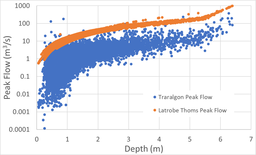
Joint probability of local creek flows, regional river flows and flood levels
Expert evidence to the C407Melb and C384Melb Planning Scheme Amendments
An expert review of the hydrology and hydraulic models underpinning the flood layers in proposed Planning Scheme Amendments of the City of Melbourne Planning Scheme. This review for the Victorian Planning Panel also provided an independent hydrology and hydraulic model of the brownfield Central Business District. This project included resolution of the joint probability relationship between Moonee Ponds Creek, the Yarra River, local stormwater runoff and tide levels in Port Philip Bay. First principles systems analysis was utilised to apply the latest climate change models from IPCC and NSAA, and ARR2019 guidance to this project.
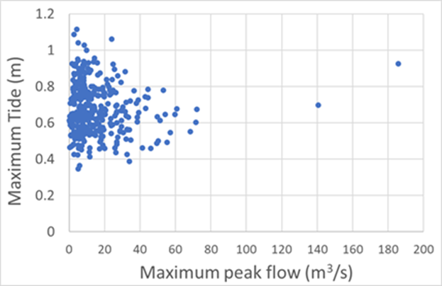
Joint probability of peak flows in a regional river and maximum tides
Resolving the hydrology and hydraulic aspects of the Wonthaggi North East Precinct Structure Plan for Bass Coast Shire Council in Planning Scheme Amendment C152.
More than 5000 housing and employment properties are proposed for a new urban growth precinct at the north east of Wonthaggi in the Bass Coast Shire. The draft Planning Scheme Amendment C152 includes a precinct structure plan, development contributions plan and native vegetation overlay. Bass Coast Shire Council commissioned Professor Peter Coombes to consider the adequacy of the drainage strategy, flood overlays and the associated costs. An expert report and evidence was provided to the Victorian Planning Panel. The Panel subsequently requested the Peter Coombes lead the development of a list improvements and revisions that would be applied to hydrology, hydraulic, floodplain management and infrastructure design aspects of the precinct structure plan.
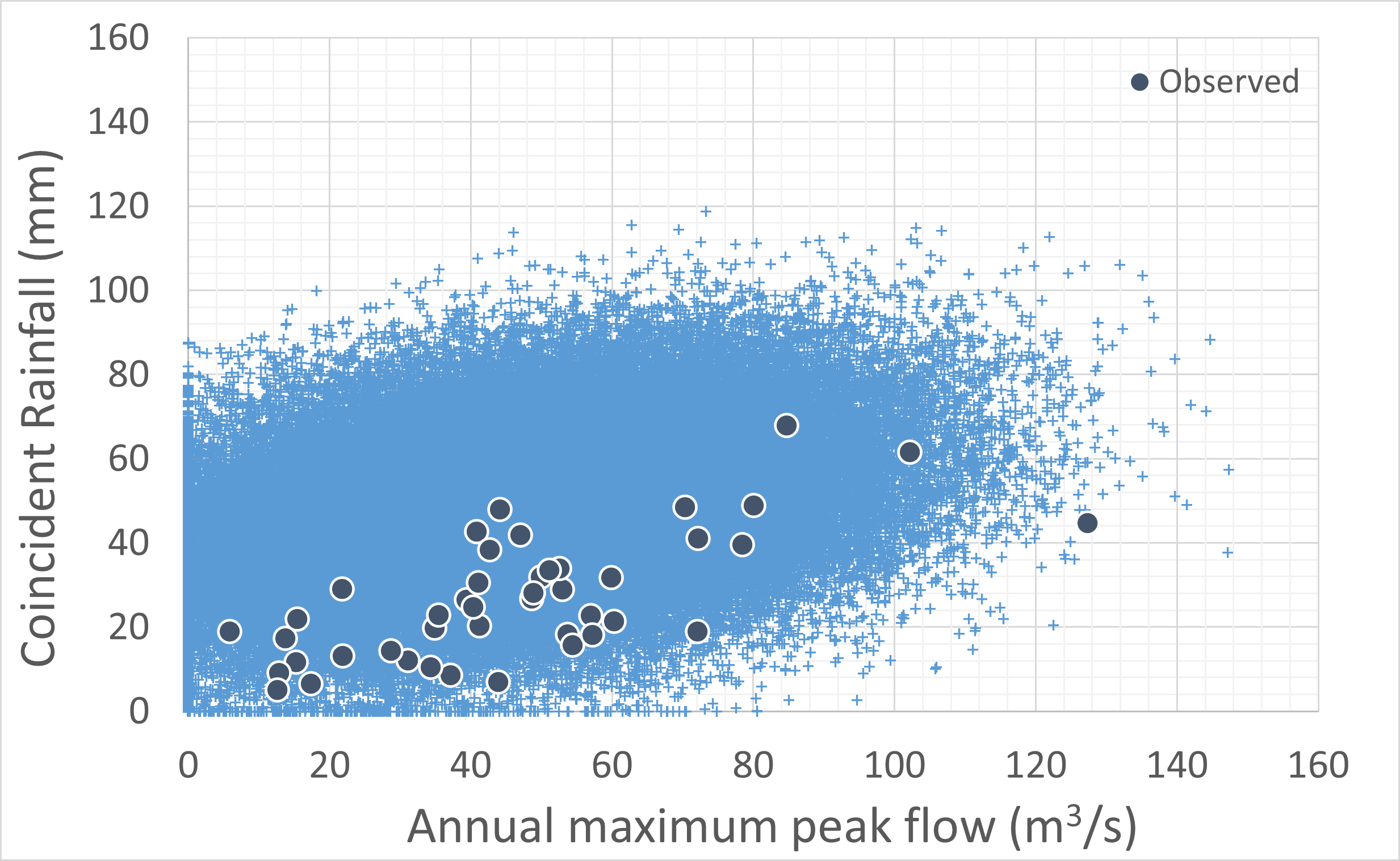
Consistent with our expert evidence, part of the area was impacted by flooding from the Powlett River soon after the Panel hearing. Peter Coombes was subsequently commissioned by Bass Coast Shire Council to resolve the joint probability relationship between the regional Powlett River, local stormwater runoff, coastal influences and climate change. The graph below shows the relationship between local rainfall at Wonthaggi North versus peak flows in the Powlett river based on observed data and Markov Chain Monte Carlo analysis. This information was utilised to assign an accurate relationship between the river and the precinct hydrology and hydraulics. This was done by specifying the hydrology inputs to the hydraulic models and by setting the appropriate tailwater levels.
Joint probability of peak flows in a regional river and local rainfall using observed data and Markov Chain Monte Carlo analysis
Stormwater management, infrastructure and flooding strategy for the DPO24 development at Inverloch for Bass Coast Shire Council.
Development Plan Overlay 24 (DPO24) applies to the land at the north western edge of Inverloch, adjacent to Ullathornes Road, Bass Coast Highway and Ayr Creek, that is the primary growth area available in township of Inverloch. The DPO24 area includes proposed developments that ultimately discharge stormwater runoff to the downstream Ayr Creek environment. Bass Coast Shire Council (BCSC) is addressing the outstanding stormwater management issues for these proposals. Council commissioned Peter Coombes from Urban Water Cycle Solutions to provide advice on the ultimate stormwater management solutions with respect to the entire DPO24 area and impacts on the downstream Ayr Creek environment
This investigation provided a stormwater management strategy for the entire DPO24 land development area that responds to whole of catchment and downstream constraints. The report is based on review of the relevant historical reports, field inspections, interviews with BCSC staff and hydrology modelling. Whilst these previous studies employed different local assumptions, this review confirmed that the various proposals will generally meet the requirements of the Ayr Creek Management Plan.
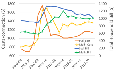
Towards equitable pricing frameworks for multi-unit buildings
The Independent Pricing and Regulatory Tribunal (IPART) regulates the tariffs that Sydney Water can levy on the properties for the provision of water, sewage and stormwater services. These tariffs vary with the type of property that purchase the services. According to the Australian Bureau of Statistics, Residential units and apartments are an increasing proportion of housing stock (31%) in Greater Sydney, and research has shown that units are associated with the increasing water efficiency of the region. There is a shortage of rental apartments in the Greater Sydney region resulting in higher rents. The provision of rental apartments in multi-unit buildings also encounters substantial financial barriers which impacts on the availability of affordable housing.
Building owners and landlords pay the tariffs for water, sewage and stormwater services on behalf of tenants. The only costs that can be passed on to the tenants of units is for water usage where individual meters are installed. Our report to provides advice and assistance on reviewing Sydney Water’s tariffs to support an application to IPART for a more equitable pricing structure. The report included feasibility analysis and economic modelling of multi-unit buildings, commercial buildings, detached housing and the provision of water utility services.
Review of the potential for cross connection and backflow from properties with rainwater harvesting
Professor Peter Coombes was commissioned to examine the changes to assessment and requirements proposed by the Australian Building Codes Board (ABCB), Standards Australia and others to properties with rainwater harvesting and utility water supplies. This investigation considered the proposed regulatory changes in the context of historical data on health outcomes associated with utility and rainwater harvesting supplies to establish differences in health outcomes. The available evidence about cross connections and backflow events with associated health outcomes was also examined.
The evidence shows that health impacts from rainwater harvesting systems are rare and the annual probability of a health impact from rainwater supply is less than the risks associated with utility water supplies. This result is consistent with peer reviewed epidemiological research that finds that the health risks of rainwater harvesting and utility drinking water supplies are similar.
There is no evidence of cross connection and backflow from properties that include utility water supplies and rainwater harvesting, and no known health impacts from these properties. Indeed, the occurrence of backflow from residential properties to utility distribution networks is very rare and contested. Installation of additional plumbing devices is unlikely to resolve the rare human errors that have connected recycled water or irrigation schemes (for example) to utility distribution networks supplying properties that needs better education of practitioners and relevant stakeholders. It is important to find the most appropriate mechanisms to protect utility water supplies.
Australian properties include utility water meters with backflow protection at the property boundary and utility distribution networks include strong regulation of pressure regimes which acts to mitigate backflow risks. Properties that include rainwater harvesting include containment protection at the utility water meter and zone protection at bypass device. These properties include four processes in series that do not permit reverse flows that have not been considered by the ABCB or Standards Australia.
Analysis of the annual probability of backflow from properties with above ground rainwater systems has revealed insignificant risks of backflow and associated health risks are highly unlikely. Properties with above ground rainwater harvesting should be considered to be low hazard and the existing configurations are adequate. There does not seem to be evidence to support the changes proposed by the ABCB which impose high regulatory impacts and costs on property owners and the rainwater industry.
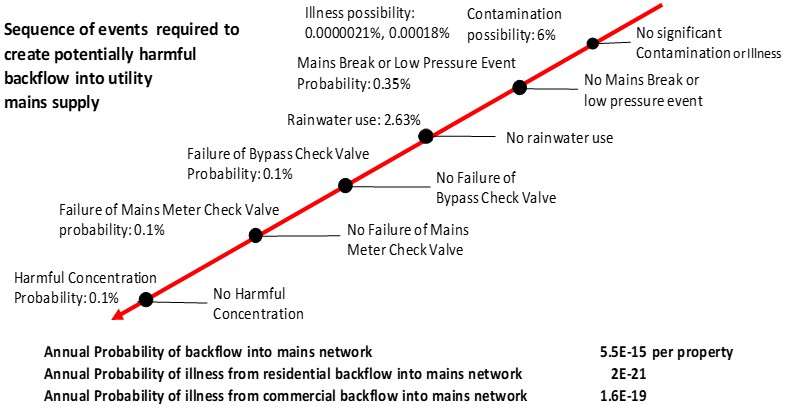
Risk pathway for possible backflow from household rainwater harvesting to utility distribution networks and potential for health outcomes
Castle Creek flood mapping and preliminary floodplain management assessment for Strathbogie Shire Council
Strathbogie Council (Council) commissioned Urban Water Cycle Solutions to establish a flood model for the main water course of Castle Creek and its downstream floodplain at the west of Euora township in Victoria and conduct a preliminary assessment of floodplain management scenarios. Hydrologic and hydraulic models were established for Castle Creek Catchment to define design flood behaviour and establish the flood risk for the 1% (1 in 100) and 0.1% (1 in 1000) Annual Exceedance Probability (AEP) design storms. The hydraulic modelling covers the floodplain near Euroa as well as the entire Creek upstream of Telford Bridge. This significantly enhanced the existing flooding information possessed by Council and Goulburn-Broken Catchment Management Authority (GBCMA), which was limited to downstream of Telford Bridge. This previous information was derived from the Euroa Post Flood Mapping and Intelligence Project.
Study outputs include maps of flood extents, levels, depth, velocity, hazard, and categories for 1% and 0.1% AEP flood events, identification and assessment of flood risks and management measures associated with existing levees and vegetation conditions, reports detailing the study methods, investigations and conclusions, hydrologic and hydraulic models, and digital datasets. Study outputs provided Council with flood intelligence that can be used in the preparation of planning controls for development applications, understanding the flood risks, and developing detailed floodplain management strategies.
The Essential Rainwater Harvesting Masterclass
Michelle Avis (Verge Permaculture) and Professor Peter Coombes (Urban Water Cycle Solutions) have provided the Essential Rainwater Harvesting Masterclass for the last five years. The series of workshops, lectures, group discussions and design tasks commences in January each year. The evidence based curriculum includes
- Systems Thinking,
- water quality, water guidelines, common concerns and getting data
- supply and demand modelling
- sizing examples
- The natural treatment train: key concepts
- The natural treatment train: roof, conveyance and tank]
- The natural treatment train: pumps, hot water and final filtration
- Codes, standards and regulators versus science (making projects happen)
- Peer review of student projects and discussion
i